About the update in January 2008:
We have been last time in Nisyros in 2006.
Really new is only a dirt road to a little church at the road between Pali
and Emborios, Agios Jorgos. Besides that we only measured some of the known
ways and corrected them in the walking map.
About the update in January 2006:
2005 we tested a new (for us) path and
put it together with some corrections and completions to the map.
About the update in November 2004:
In 2003 and 2004 we were in Nisyros with
our children. In 2003 we took a childrens carriage (for two children sitting
behind each other) with us, so we could use only the asphalt roads. In
2004 our children walked by themselves, that's why we could do "real" walkings
again.
The road to the Lies-beach is now completely ashalted, just as the road to Avlaki. Near Emborios a new gravel road up to the cemetery and to the upper part of Emborios was built. From Panagia Kira to the Lies-beach there is a new additional large walking path, which was originally planed as a road, but is partly disappeared under stones and soil or broken down. Near Nikia a new church was built up the mountain (named again "Profitis Illias"). There is now a new gravel road branching off the road to the monastery "St. Johannis Theologos".
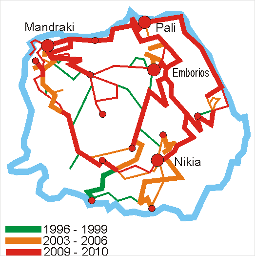
Additional informations aubout the map:
The walking paths on Nisyros permanently
change, unfortunately not always to the favor of the walking people. Because
of the growing holly and the collapses of the walls the paths condition
is not always the same as we found at our last walkings. The notations
"fixed ", "pavement", "not fixed" or "without any path", respectively "road"
(wide enough for a car) or "path" (only for pedestrians) are based on our
last walking. The graphic shows the age of information about the ways on
our map. In the years shown, we used the ways by ourselfs and reported
their condition.
Backgound and labeling of the map:
The shore line and the isometric lines
we took out of a graphic in an geological article, published in the NISURIAKA
CRONIKA in 1958 . Thanks to Prokopis
Karpathakis for the translation and correction of the greek labeling, as
well as for the references to the original Nisyrian names for locations
and landscape, as well as for leaving a reprint of the NISURIAKA
CRONIKA to us.